Coast to Coast walk Day 1 – dipping our toes in the Irish Sea
Click here to track our progress live
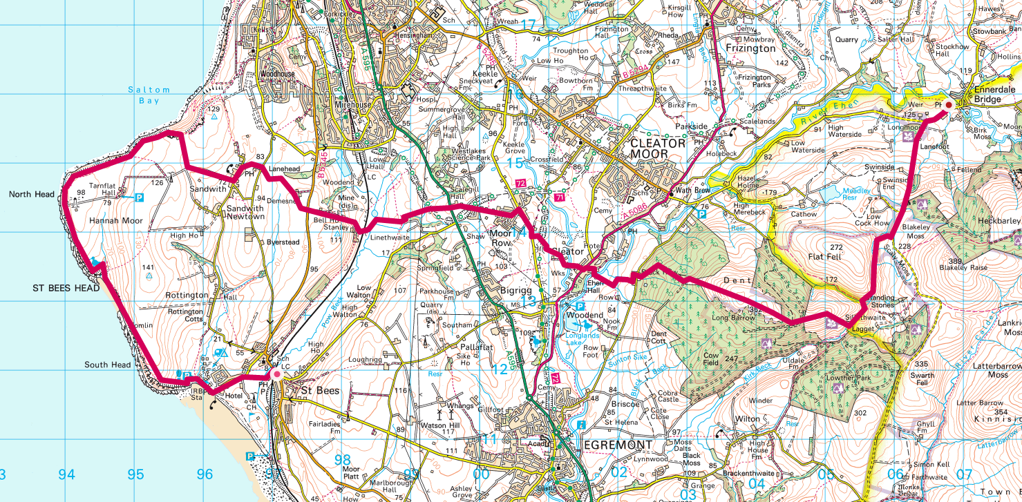
Coast to Coast walk day 1 involves dipping our boots into the sea at St Bees. A short climb up to St Bees Head with Hannah Moor to our right. Weather permitting we should be able to see the Isle of Man on the horizon and the Winscale (Sellafield) nuclear power station. They renamed it from Winscale when I was a kid to avoid the bad reputation it had gained. We walk around the headland past the lighthouse and then proceeding inland towards Ennerdale Bridge.
At Cleator the perceived wisdom is that we stop at the Cleator Family Store to support the local economy. They have a walkers log book to sign. It will be interesting to see how many have been before us this year. The walking season is only just beginning.
We are using the Martin Wainwright Coast to Coast Walk guide book. No relation to Alfred Wainwright. The guide book suggests there is a 705m climb (775m according to the Ordnance Survey route I’ve plotted) on this day. I think there are few days that don’t involve going upwards which is going to be the real test of my fitness. The first real climb starts here up Cleator Moor where, at the top of which, we should get a good view looking back at the coast.
Our final destination today is Ennerdale Bridge which the book says is 13.8 miles (22.1km) in. I think this should be a nice manageable start to the adventure.
I’ll post an update this evening to tell you how I got on.
Update
What a start to the odyssey. The day began in a raging gale and ended up in a raging gale. The runkeeper live tracking stopped, probably due to zilch connectivity, the phone eventually ran out of battery and wouldn’t recharge using an external battery. This became a problem when we thought we might be lost – at 6.30 pm. I also dropped the phone and smashed the back of it – not sure what that does to the waterproof qualities. I also lost my specs having removed them on top of St Bees head to get better visibility. There was nowhere dry to stop for lunch, or any break really and we didn’t eat much of our packed lunch (ham sandwiches & accessories). The walk up Dent was a killer with zero visibility at the top and where we had to resort to the use of the compass – a couple staying at the B&B said they avoided Dent and it took them an hour and a half from Cleator (took us 4hrs 10 minutes. Nannycatch Brook was mostly flooded with many fords that might normally be an easy crossing being raging torrents. The boots got wet at that point if they weren’t already. This morning the boots are still wet and I’ve changed the paper on mine and Tom’s. There is zero connectivity – either mobile or fixed. The B&B’s phone line is down and even in the pub the wifi was so slow as to be unusable.
Ajax and Luke got in at 5.30!
The positive points? We got the worst of the weather out of the way and we finished a day that turnedo ut to be a real challenge. We staggered down to the Fox and Hounds and had food with the Agius’. I had a steak and ale pie with chips and veg. Tom had gammon steak. We saw lots of sheep but bugger all else and Tom was invaluable with his map reading.
Monday is another day. The forecast is rainy for the morning but clearing u thereafter. See how it goes.
| starting B&B | Stonehouse Farm, 133 Main St St Bees CA27 0DE |
| forecast/actual km | 23.14/23.25 |
| forecast/actual time | 7hr 55mins/8hrs 6mins |
| weather | atrocious – driving rain gale force winds |
| forecast/actual ascent m | 775.7/880 |
| breakfast | full English, did the job. |
| lunch | ham roll & stuff |
| dinner | steak pie and chips in fox & houns Ennerdale Bridge. Top notch |
| finishing B&B | Thorn Trees, Ennerdale Bridge, CA23 3AR – helpful |
Link to Coast to Coast walk Day 1 Google Photos Album. Photos will upload as soon as there is connectivity and I will move them into the shared album each evening when I get to the pub for dinner or if there is a decent connection, periodically as we go along.
While I am walking I will be using Runkeeper to live track my progress. You can find the link for each day’s progress at my twitter page or at my Facebook profile page. I will also be pinning photos within Runkeeper as I progress. I am also using a Fitbit Surge to provide me with additional monitoring data.
Don’t forget I’m raising cash for Cancer Research UK whilst on this Coast to Coast walk. JustGiving page here. The start date of the walk coincides with the anniversary of my mother’s death on May 1st last year. Mam was Chairman of the Marown & District branch of the IoM Anti Cancer Association.
Forecast numbers are based on Ordnance Survey mapped route. I add 1 hour for each approx 500m climb plus an hour for lunch.
A lot of people have helped me in the preparation for this walk. Firstly Mat Kiddie of Amigo who I met on a plane coming back from Mobile World Congress and who sent me a mobile battery charger. Then there is Aideen O’Colmain of Fitbit who very generously donated a Surge. Finally there is Dan Cunliffe and his team at Pangea who provided me with a mobile tracking device that allows me to track my progress independently of having to use my phone.