Coast to Coast walk gadget review
Coast to Coast walk gadget review includes Samsung Galaxy S7 Edge, Runkeeper, OS Maps online, Fitbit, Pangea Tracker and the Leatherman multitool. I carried with me a number of gadgets and used 2 main Apps on the coast to coast walk. Here’s what I thought of them.
The Edge was bought several weeks prior to the coast to coast walk as my Oneplus2 had failed miserably in the rain during the Llanberis training week. In fact it died on me. The edge claims to be waterproof and can withstand being under 5 feet of water for up to 30 minutes.
I tried it out in the rain before going o the walk and had no problems. The camera is brilliant and the phone feels great to hold.
Under true field conditions the problems showed themselves. Firstly the rain was so heavy that every time a raindrop hit the screen the phone thought I was pressing a button. It went haywire. This was particularly inconvenient when I needed to use the GPS.
At our lunch stop under a soaking wet railway bridge I dropped the phone and subsequently found I’d cracked the back. At least the screen survived for me to be able to use it on the rest of the walk.
The phone was kept in my waterproof coat pocket. This pocket filled with water because I left the zip open to access phone/gloves/stuff. This didn’t particularly seem to affect the phone but the battery did run out during the afternoon and my external charger wouldn’t work because the phone detected “moisture in the USB port”. The next day I left the phone in a dry bag in the rucksack and used my GoPro in it’s waterproof case.
The GoPro worked fine but needed the images and videos manually backing up which was a faff.
After day two the weather was near perfect so I reverted to the use of the phone which I kept wrapped in my merino buff, really just to prevent condensation (from my profusely sweating body) getting to the screen and affecting its responsiveness to my finger. I needed fast responsiveness to be able to quickly take pics.
At around the middle of the afternoon I’d retrieve the external charger from the dry bag and plug it into the phone. One charger with 7800mAh was enough but not over the top. After a couple of days I left the second spare power pack in my main bag that was transported between B&Bs.
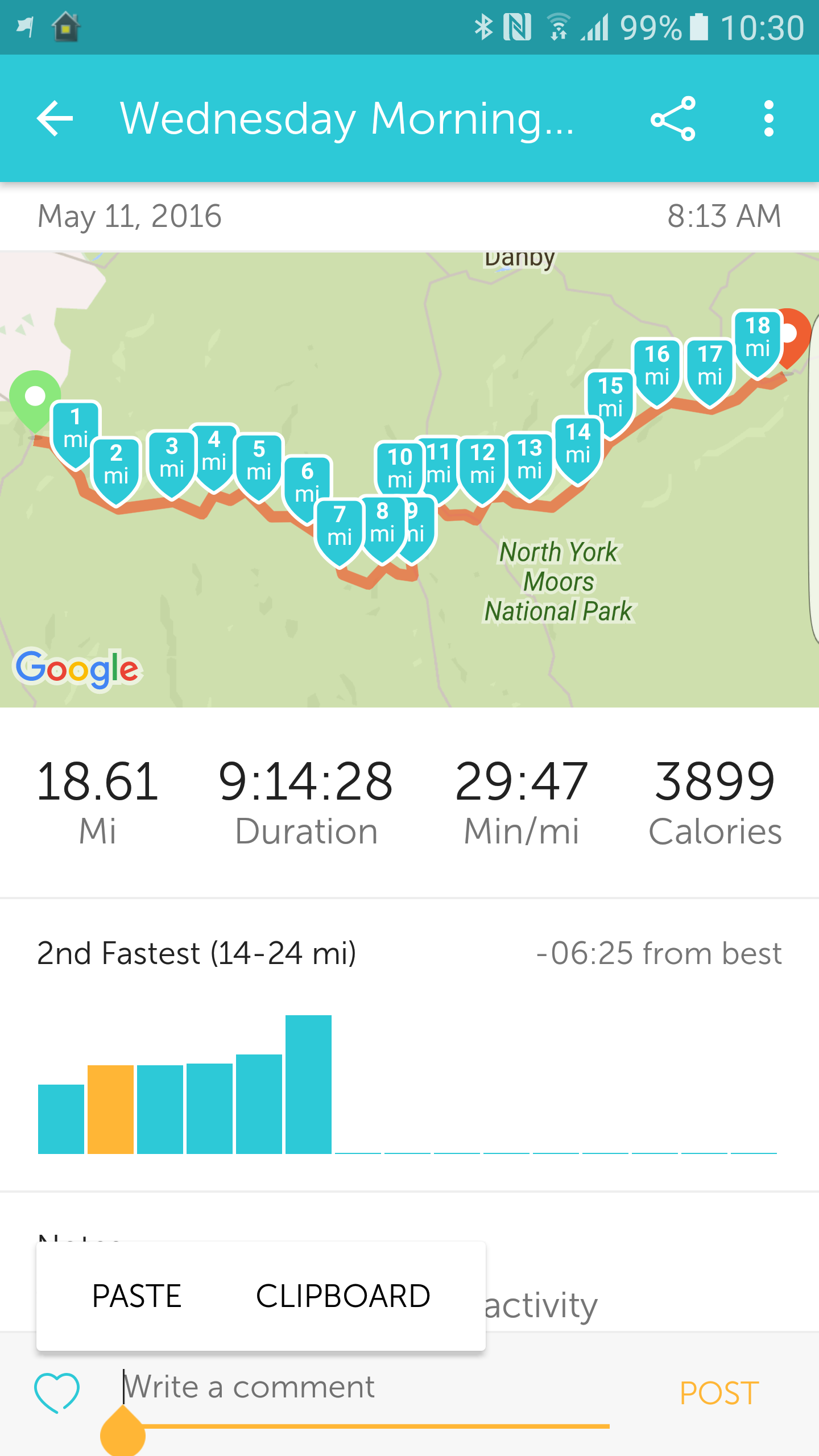
Apart from the camera, which with 36GB of pics and vids taken was the most used app, the most useful app was Runkeeper. Runkeeper told us how many miles we had come and therefore how many we had yet to go. It also told us how long we had taken and the miles per hour walking rate. This was all important info especially as we needed to try and keep up the pace over the long days and distances. My overall pace was hampered by heel blisters that slowed Tom and I down over the 12 days.
I was also able to broadcast our progress live using Runkeeper. Once the activity had been started, son Joe at Newcastle University would log in, take the link and insert it in the day’s pre-written blog post. Images and videos, uploaded in real time where there was connectivity, would also be transferred into the pre-created album of the day.
Connectivity was very poor along most of the route. Bear in mind Wainwright (forever labeled Wainwright the sadist in my mind) took you away from roads and up steep sided mountains wherever possible. The Lake District connectivity was especially poor, both mobile and fixed. In the interest of survival and resting my knee, hammered on the day 2 descent from Honister, Tom and I sometimes took an alternative route by road, avoiding rocky descents.
Poor connectivity didn’t stop the Runkeeper tracking from working. It would just wait for some bandwidth availability before updating the online database.
The other great app I used was the Ordnance Survey online mapping tool. Before the trip I created the exact replica of Wainwright’s route for each day using the tool. This was then downloaded onto the phone for offline use. Essential for a route with little connectivity. The absence of mobile data connectivity didn’t stop the GPS from working. Whilst we mostly used a paper map we did find it very convenient to resort to the Ordnance Survey which would then tell us whether we were off course or not. This saved us time and effort on quite a number of occasions and I very much recommend it if you are into the outdoor recreation game. I wouldn’t rely on the OS Maps app as the main navigation tool. It feels like it uses a lot of battery power although I have no data to back this up. Also in the rain it is safer to use a map securely stored in a waterproof map case or even a waterproof map.
I had with me a Fitbit Surge watch. Tests had determined that whilst this did work as a tracker the battery life was not sufficient when using GPS. The latest we got in was 8.15 pm on the second day. The phone battery could be supplemented by the external charger but this was not possible with the Fitbit as the socket was underneath the display, ie resting on your wrist.
The Fitbit would be great for the intended usage – running, working out etc where the times involved might be in the lowe hours rather than days.
I carried with me at all times the Pangea Tracker. This gave me a reliable backup for Runkeeper and also a portal that will allow me to access the whole route when back at base and with some time to properly write up the whole walk (whenever that might be!).
Other gadgets worth mentioning include the Leatherman multitool. I only used it once and that was in the evening at the B&B. Whilst being a really cool boys toy it didn’t take me long to decide that less weight was better than invisible coolness and this was soon relegated to the duffel bag and the transporting van.
The duffel bag btw was a North Face Basecamp XL. Fantastic bags. Really robust. As well as my clothes it also carried my Osprey laptop bag. I used one of my Chromebooks during the evenings, exhaustion permitting, to update the day’s blog. The chromebooks are so cheap as to be almost disposable and taking it along was an acceptable risk.
I think that’s it on the coast to coast walk gadget front. I used the premium, paid for versions of Runkeeper and the OS maps.
The coast to coast walk has been a major feature in my life for the last few weeks. Check out all the posts in the coast to coast category on this blog.