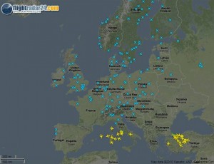
Live air traffic control radar data as of 7.45am Saturday 17th April. Nothing to do with IP Communications although everything to do with the internet I guess.
An x represents an airport, a plane is a plane. The map shows how the Icelandic volcanic ash cloud is affecting air traffic in Europe – only a few airports in the south are open. Check out what it looks like now here.


4 replies on “Radar map showing real time flight information – effect of Icelandic volcano”
I was thinking about this earlier, whilst looking at the empty sky…
… I remember having to book a telephone call. I remember the ‘operator’. I remember getting a phone in the house, and getting my own line instead of a party line. I remember getting a mobile.
Now I see us scratting around for bandwidth and not being able to video conference on pi**poor connections and wonder if in my lifetime I will see Next Generation Broadband which will cut down on flying to meetings and enable people to interact in real time without leaving a massive carbon footprint on our planet. http://www.informationisbeautiful.net/2010/planes-or-volcano/ shows the footprint of european flights…
… bring on the fibre, both moral and optic. Digitalbritain needs men of grit to play the eNdGAme.
V interesting link.
Hi, interesting link. I came accross a similar site which has a representation of the ash cloud on it at http://www.radarvirtuel.com
Check out my blog at http://rcarey.co.uk for more information.
So in effect what you are saying then that is to save the world we need more volcanic action. Cyberdork = FAIL